Moa Jamir
Dimapur | September 12
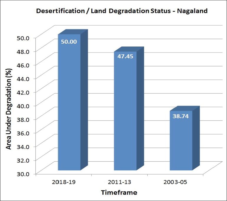
Exactly 50% of the total geographical area of Nagaland was undergoing Desertification/Land Degradation (DLD) during the timeframe 2018-19, revealed the latest ‘Desertification and Land Degradation Atlas of India’ published by the Space Applications Centre (SAC), Indian Space Research Organisation (ISRO), Ahmedabad.
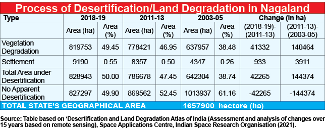
According to the Atlas, out of the State’s total geographical area (TGA) of 16, 57,900 hectare (ha), 8,28,943 ha was undergoing DLD during the assessed period.
It was further revealed that area under the process of DLD in Nagaland over the last 15 years has been increasing.
For instance, in 2003-05, at 6,42,304 ha, area under DLD was just 38.74% of the State’s TGA; however, it increased to 7,86,678 ha or 47.45% during 2011-13, or an increase by 8.71% (1,44,374 ha) during the intervening period.
In around 6 years, the DLD area increased by 2.55% (42,265 ha) to 50% in 2018-19.
Land degradation is decline in productivity of land in terms of “bio-diversity and economy, resulting from various causes including climate and human induced factors, leading to loss of ecosystem,” the Atlas explained.
Desertification is referred as land degradation occurring in arid, semi-arid and dry sub-humid regions and the United Nations Convention to Combat Desertification (UNCCD) had identified it as one of the most challenging environmental concerns of the present and future, it added.
The Atlas was officially released on June 27 on the ‘Desertification and Drought Day’ but was made available in the public domain only recently.
Chief contributor to DLD in Nagaland
As per the latest Atlas, the most significant contributor to the process of DLD in Nagaland was vegetation degradation, gradually increasing during the last 15 years under observation.
In 2003-05, vegetation degradation contributed to 38.48% of DLD, which increased to 46.95% in 2011-13. In 2018-19, it contributed 49.45% or 8,19,753 ha of area under DLD, while human settlement contributed 9,190 ha or 0.55%. (See table)
“Between timeframe 2011-13 & 2018-19, increase in forest area undergoing vegetation degradation is observed. The same trend is observed between timeframe 2003-05 & 2011-13,” it noted.
According to the SAC-ISRO classification, vegetation degradation is “referred as reduction in the biomass and/or decline in the vegetative ground cover, as a result of deforestation and/or overgrazing.”
“Such degradation is a major contributory factor to soil degradation particularly with regard to soil erosion and loss of soil organic matter,” it said, while noting that “vegetation is an important factor in the protection of soil and soil fertility.”
Destruction of vegetation accelerates soil degradation leading to its degradation. When a soil loses vegetation cover, it becomes more susceptible to wind and water erosion, it added.
Agriculture observed within forest lands has also been classified under vegetation degradation.
Other forms of ‘natural’ DLD included water erosion, water logging, soil salinity, mass movement, and frost heaving and shattering.
Desertification processes induced “directly or indirectly by human intervention” are categorised as manmade. It included activities such as mining/quarrying, brick kiln, industrial effluents, city waste, urban agglomeration etc.
NE and All-India Status
While Nagaland is among the six states—Jharkhand, Rajasthan, Delhi, Gujarat and Goa showing 50% or more area under DLD, with respect to their total geographical areas, most of the North East States showed better status with Arunachal Pradesh leading at just 2.40% DLD, followed by Assam (10.64%), Sikkim (11.92%), and Mizoram (13.08%).
At 42.66%, the DLD in Tripura was also concerning while in Meghalaya and Manipur, the rates of DLD were 24.86% and 27.44% respectively.
“The blend of high population, high agriculture production and diverse agro-climatic conditions create a scenario of excessive pressure on land and raise the risk factor for degradation of land in India,” the report noted.
Accordingly, the country level DLD map prepared by integrating States’ maps highlighted that 97.85 million ha or 29.77% of the TGA of the country is undergoing DLD during timeframe 2018-19, the report said.
It is an increase from 96.40 million ha (29.32% of the TGA) in 2011-13 and 94.53 million ha (28.76% of the TGA) in 2003-05.
The most significant process of the DLD in the country in 2018-19 was water erosion (11.01%), by vegetation degradation (9.15%) and wind erosion (5.46%).
The DLD Atlas
The Atlas is one of the outcomes of an ongoing Department of Space (DOS) funded national project entitled, “Desertification and Land Degradation: Monitoring, Vulnerability Assessment and Combating Plans”, being executed by the SAC, ISRO, Ahmedabad along with 15 concerned Central/State Government departments and academic institutes.
The current Atlas presents State-wise DLD Status Maps, prepared using on-screen visual interpretation of Indian Remote Sensing Satellite (IRS), Advanced Wide Field Sensor (AWiFS) data of 2018-19 timeframe in GIS environment, the SAC said.
The analysis of changes on the status of DLD has also been carried out with previously available inventories of DLD for timeframes 2011-13 and 2003-05, it added.
The Atlas is aimed at serving not only as a ready reference, but strengthening the envisaged National Action Plan for achieving land restoration targets by providing important baseline and temporal data and technical inputs.
As a signatory of the UNCCD, India’s national commitment to land degradation neutrality is “restoring 26 million hectares of degraded land by 2030.”