Limalenden Longkumer
Mopungchuket is located just 19 kms away from Mokokchung Town and is connected by beautiful motorable roads, cut through the deep forests teeming with greenery. Situated on a hill-top, Mopungchuket is surrounded by panoramic views of paddy fields and almost every conceivable inch of the hills are hedged by lush sub-tropical forests that stuns the eye with shades of green. The village is blessed with pleasant climate and one can visit this beautiful inhabitation anytime of the year. The village offers an impressive view of classic rural and urban look- an admixture of the past with the present.
Mopungchuket has exquisite natural scenic beauty coupled with historical places worth exploring. It is a land of folklore passed down the generations orally. It is also the land where the ancient tragic love story of Jina and Etiben was immortalized. With time, Mopungchuket has become the destination of choice and attracts tourists from far and near.
On a clear night, the views of the constellations are spectacular and the sunrise over the magnificent hills of Langpangkong Range is simply breathtaking. One will also be enchanted by the calm and serene view of the mist hanging mysteriously around the hills surrounding the village.
A visit to the greenery of Mopungchuket and resting a few days and nights in the midst of virgin forests, rivers and wildlife will definitely instill new life and inspiration in a tourist for ever. The vast texture of massive trees giving birth to varieties of orchids, wild fruits and rarest plants and resounded with echoes of birds and wild animals make it a veritable paradise for lovers of nature. There is no comparison to actually being there – with the smells, sounds and the air of the “aremsanem” (enigmatic phenomenon of the Naga forests) engulfing you!
In the midst of nature’s blanket of green, the village community also maintains a picnic spot some 3 kilometers down south of the village at Mangkolong. If one is to follow the road down to Mangkolong, the temptation to stop at each of the mystifying wonders of nature must be resisted so that there is enough time to visit such places back in the village as the Jina and Etiben Memorial Tower, Süngkong, Ariju, Süngkotenem, Longrangtenem Park and the Village Museum.
The Ao Naga code of ethics circle around “Sobaliba”, an untranslatable term governing every citizen and obligating everyone to be selfless, honest, cultured, hospitable, patriotic and helpful to others. “Sobaliba” to a citizen of Mopungchuket stands for that compelling moral force which finds expression in self-sacrifice for the service of others and exercise of self-control over self-expression.
Mopungchuket has a unique feel. Things move slowly, a function of both the highland topography and the “make do with whatever you have” attitude most villagers of Mopungchuket embrace. The result is a relaxing, easy-going village with friendly people, beautiful alleys and plenty of areas to explore. The view of the surrounding gorges and hills or the smiling children of local ethnic villagers soaked in utter simplicity will give you a sense of total fulfillment. Another major attraction is the ethnic culture of the village manifest in so many forms including folk songs and folk dances. With the dawn of modernity, the social fabric and the landscape of Mopungchuket has undergone tremendous change over the years.
Consider yourself forewarned: Ao Naga food is bland. Often, the food is pungent and garlic is the only spice used. There’s plenty of pork, beef and chicken, as well as rice and vegetables. Vegetarians will find themselves eating rice and umrem-mongmong everyday.
The cheapest and by far the most enjoyable activity in Mopungchuket is to put on a pair of sturdy shoes and just walk. The streets of Mopungchuket are full of characters.
Geography and Climate
The village of Mopungchuket lies in the central regions of the district of Mokokchung, Nagaland, and is bounded by Chuchuyimpang and Khensa villages in the South, Chungtia and Khar villages in the West, Longjang and Longpha villages in the North and Sungratsü village in the East.
Mopungchuket extends from 26˚33’N to 94˚24’N latitude and from 94˚31’E to 94˚33’E longitude. It is situated at an altitude of 1,324 meters above sea level.
The village is located on one of the hill-tops of Asetkong Range under Mokokchung District of Nagaland. The terrain of the village is steep and the slopes vary from 10˚ to 45˚. The village is drained by numerous streams which flow into the two tributaries of Milak River, namely, Longrangtsüshi and Tsüsü.
Mopungchuket falls under the sub-tropical rainy climate region (AM Type). As such, the village is characterized by a consistent climatic condition with seasonal rainfall. The climate is moderate with temperature varying from 10˚C to 30˚C through out the year. The seasonal monsoon rainfall occurs between the months of May and September. The average rainfall is measured at 240 cms per annum.
Historical Background
The village is believed to have been founded during the 10th or 11th century AD. The exact period of its foundation is unable to be ascertained due to lack of written historical accounts. As per oral records, the early settlers of the village migrated from the South-east from Chungliyimti, presently under the District of Tuensang, Nagaland, via Aonglenden, Ungma and Mokokchung villages.
The village is one of the most developed villages in Nagaland today and has a lot of historical landmarks that finds mention in Ao Naga folklore.
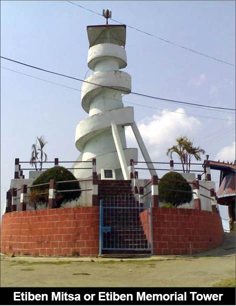
Jina and Etiben, the legendary lovers in Ao Naga folklore lived and died in this village. The lovers’ songs are still sung today and monuments are being constructed in their honour.
There are historical accounts of relationship between the Ahoms (or Assamese) and Mopungchuket. The Ahoms named Malauthupia (or Molotobia) for Mopungchuket. Written accounts of the relationship between Malauthupians and Ahoms are found in the Ahom Buranjis, the Chronicles of Ahom Kings.
The Ahoms invaded Mopungchuket in 1832 AD during the reign of King Purandar Simha. The invading Ahom soldiers failed to over power the fierce warriors of Mopungchuket. Legend has it that the Spirit of Süngkotenem, supposedly the deity and keeper of the village and worshipped by the village folks during those days intervened in the battlefield. The Ahom soldiers fled the scene leaving behind their swords and armouries. The warriors of Mopungchuket chased them down to as far as the plains of Tsürang, bordering Assam. The swords left by the fleeing Ahom soldiers are still preserved in the Village Museum and stands proof to this fact.
The village is adjacent to Impur Mission Center founded by the American Missionaries in 1884. American Missionaries Dr. & Mrs. E.W.Clark, the first Christian Missionaries to the Ao Nagas established Impur under Mopungchuket village territories with the blessing of the village elders. The establishment of Impur Mission Center was fundamental to the spread of Christianity and education among the Nagas as a whole.
Fact File
Village: Mopungchuket
Population: 8,709 (1991-2001 census)
Languages: Ao (local dialect), English, Nagamese.
Nearest Town: Mokokchung.
Distance: 19 Kms NE of Mokokchung
Mopungchuket almost touches the Kohima-Mokokchung-Jhanji National Highway No.61
Getting There:
Indian Airlines and a host of other domestic air services operate on the Delhi-Kolkotta-Dimapur and Delhi-Kolkotta-Jorhat routes.
Nearest Airports and Rail Stations are:
Dimapur, Nagaland, India – 220 Kms from Mopungchuket.
Jorhat, Assam, India – 100 Kms from Mopungchuket.
NB: National Tourists need Inner Line Permit (ILP) to enter Nagaland, issued by the Magistrates.
International Tourists need Restricted Area Permit (RAP) to enter Nagaland, issued by the Home Commissioner, Nagaland.
Where to stay
You can find yourself lodging at Travelers Inn, a decent guest house with modern amenities at affordable prices. Basic local recipes are served at the inn itself.
What to see
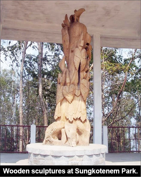
• Wooden Sculptures and pillars at Süngkotenem Park
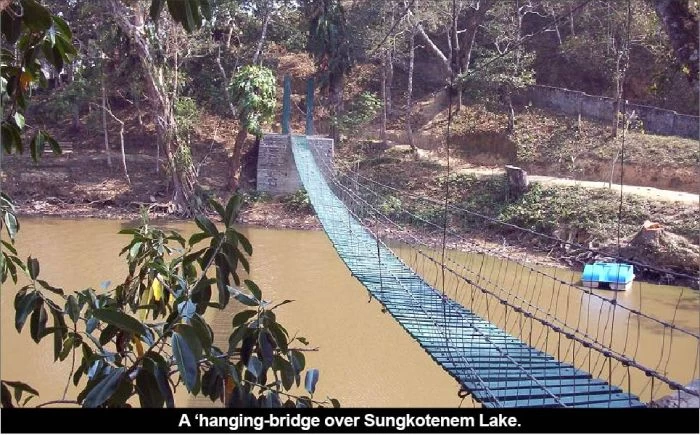
• The ancient mythological lake of Süngkotenem still exists today.
• Mangkolong Picnic Spot.
• Jina and Etiben Memorial Towers erected in memory of the legendary lovers of Ao Naga folklore, Jina and Etiben.
• The village Baptist Church building, an admixture of indigenous and modern Naga architecture. Also hung here is the largest Church bell in the Naga country.
• Süngkong or Log-drums. These are giant drums carved out of single logs that were used during the ancient days. They were beat in various tones by the folks during festive occasions and emergencies.
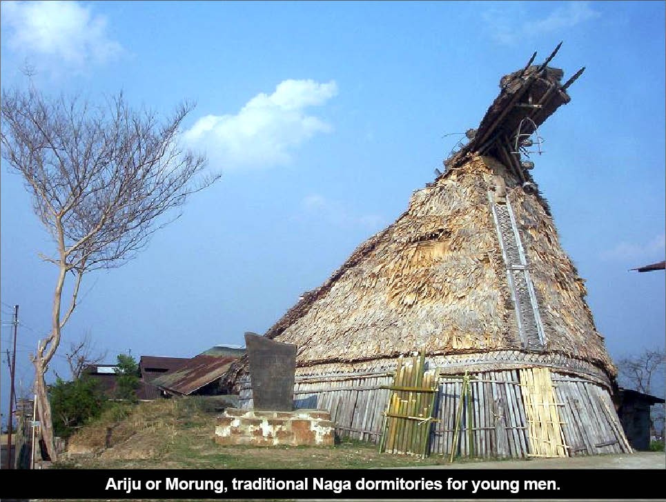
• Ariju or Morung, traditional Naga dormitories for young men.
• The Village Museum.
• Longrangtenem Park.