Morung Express Feature
Noklak District was officially inaugurated by the Chief Minister Neiphiu Rio on January 20 as the 12th district of Nagaland, three years after it was created on December 21, 2017.
‘Created on December 21, 2017 and Re-notified on July30, 2020,’ read the foundation stone unveiled by Rio on the occasion, somewhat reflecting how things unfold in Nagaland.
At the inaugural ceremony held at Public ground Noklak Hq coinciding with the Khaozaosie- Hok-Ah festival of the Khiamniungan community, the CM christened it the ‘Frontier District’ of Nagaland, due to its location in the international boundary with Myanmar, connecting to other East and South East Asian countries.
Despite years in making, information of the district is yet to be updated on most Government’s websites including the official State’s portal www.nagaland.gov.in while a profile of district on the State’s IPR has no information when last accessed.
The Noklak District Administration, however, informed that it is in the process of coming up with dedicated portal as well as data on the district.
The timeline depends on National Informatics Centre (NIC) and the district is following up, it added.
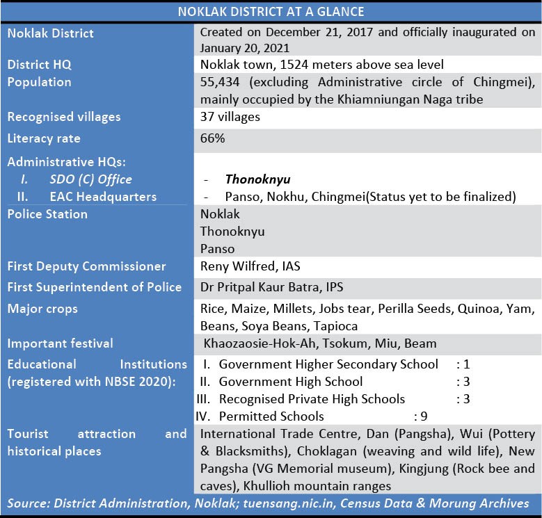
The District Administration also provided some basic information on the district (see table) and incorporating those along with other available data, The Morung Express presents a brief profile of Noklak District.
Geographical profile
Noklak is located in the easternmost part of Nagaland, bounded by Tuensang in the North and North West respectively, Kiphire in the south, and Myanmar in the most part of the east. It is mainly occupied by the Khiamniungan Naga tribe.
Craved out of Tuensang district, it comprises of areas mostly under erstwhile Noklak sub-division.
One of the original three districts in Nagaland, along with Mokokchung and Kohima, over the decades, Tuensang has been divided into four districts - Mon, Longleng, Kiphire and now Noklak.
Information via Google Maps informed that the Noklak Town, the District Headquarter, located at an altitude 1524 meters above sea level, is 54.7 km its previous HQ, Tuensang via National Highway 202.
It is 280.2 km away from State capital Kohima via NH202 and NH2.
According to 2011 Census ‘District Handbook,’ Noklak’s (Tuensang) topography as a whole is hilly and it does not adjoin any plain area.
The climate varies from subtropical to Sub-temperate with annual rainfall ranging from 800-3500mm.
In winter the night temperature sometimes comes down to 1°C during December and January which are the coldest months. In summer, the average temperature rises to about 25°C (74°F) and July is the hottest month of the year. In terms of vegetation, broad leaved hill forests are found prominently in Noklak areas.
Birth of a district
After the re-notification in July 2020, the Home Department appointed Reny Wilfred as the first Deputy Commissioner of the Noklak district while Dr Pritpal Kaur Batra, IPS was designated as the first Superintendent of Police.
The first meeting of Noklak District Planning and Development Board (DPDB) was held at DC Conference Hall, Noklak on October 27 under the chairmanship of DPDB Noklak Chairman & Advisor, Prisons and Printing & Stationery H Haiying.
In November 2020, the State Bank of India (SBI) was assigned as the Lead Bank Responsibility for Noklak district by the Reserve Bank of India.
Correction:
The table in the earlier version of the article stated that there were one police station and one police outpost in Noklak district. As per an official update, it is clarified that there are 3 police stations in the district - Noklak, Thonoknyu and Panso. The table has been updated accordingly to reflect the correct figure.